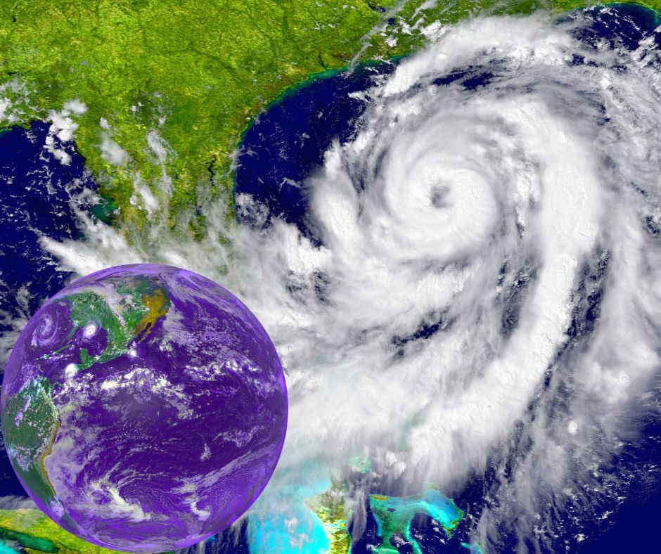
Summary: The World Meteorological Organization has warned that climate change is predicted to increase the frequency and intensity of significant tropical cyclones worldwide. Nine million people in Japan were evacuated as a result of Typhoon Nanmadol. Hurricane Ian is the first storm to hit the US mainland this season. US National Weather Service warns of severe wind damage, a life-threatening storm surge, and catastrophic floods when Ian gets onshore. Parts of central Florida are likely to see catastrophic flooding. WMO emphasised that reducing casualties during extreme weather events depends on precise early warnings and coordinated early intervention.
The two tropical cyclones quickly followed Hurricane Fiona, the most powerful storm to have impacted Canada and the cause of disastrous flooding in the Caribbean. Nine million people in Japan were evacuated as a result of Typhoon Nanmadol.
Traces of climate change
The World Meteorological Organization has cautioned everyone that climate change is predicted to increase the frequency and intensity of significant tropical cyclones worldwide.
The effects of coastal flooding are also getting harsher due to sea level rise and coastal urbanisation.
Cyrille Honoré, the WMO’s Director of the Disaster Risk Reduction and Public Services branch, cautioned that “the human and socio-economic repercussions of these cyclones will be felt for years.”
Lan, a hurricane
On September 27, Hurricane Ian landed in Cuba as a Category 3 hurricane. Its sustained winds of 205 km/h and even stronger gusts caused mudslides and flash flooding.
According to the UN Resident Coordinator’s Office, an estimated three million individuals have been affected.
Although only preliminary evaluations have been made, according to the World Meteorological Organization (WMO), Cuban President Miguel Daz Canel said that Ian would certainly cause substantial damage.
There were no reports of casualties right away. However, there was significant harm to the nation’s telecommunications, housing, agriculture, and infrastructure, with descriptions of power outages across the board. Pinar del Ro, the most severely affected province, is where 75% of the nation’s tobacco production, a significant export for Cuba, and roughly 40% of its bean production are produced.
High alert in Florida
Ian is a powerful category four hurricane with maximum sustained winds near 155 mph (250 km/h) and higher gusts. Ian is fast intensifying. This intensity is anticipated to continue.
This season’s first storm to hit the US mainland is named Ian.
The US National Weather Service warns of severe wind damage, a life-threatening storm surge, and catastrophic floods when Ian gets onshore.
Forecasters predict that the storm surge and tide will force ordinarily dry areas near the coast to become inundated by rising seas flowing inland from the shoreline. In the worst-affected locations, the water could rise to 12 to 16 feet (3.5 to 4.8 metres).
Florida’s central and northern regions will experience significant rainfall through Thursday as the storm is expected to slow down. Ian is scheduled to arrive in some areas of the US Southeast this weekend and later this week (1-2 October).
Parts of central Florida are likely to see catastrophic flooding, and northern Florida, south-eastern Georgia, and coastal South Carolina will also experience significant flooding.
Because of its magnitude, power, and landfall in a densely populated, low-lying area, Ian “poses an extreme threat,” according to the WMO.
Storm Noru
Typhoon Noru, also known as Karding in the Philippines, made landfall in the eastern hemisphere on September 25 as a “super typhoon” with sustained winds of 195 km/h (121 mph). It then moved through the central island of Luzon.
According to a disaster investigation, the worst-hit areas are home to more than two million people, and almost 430,000 were directly harmed. Even with the relatively short mobilisation period, thousands of people were safely evacuated, reducing the number of fatalities.
Typhoon Noru moved into Viet Nam from September 26 to 27 and intensified.
A critical role for early warnings
The WMO emphasised that reducing casualties during extreme weather events like Hurricane Ian, Fiona, and Thyphoon Noru depends on precise early warnings and coordinated early intervention.
According to WMO Secretary-General Prof. Petteri Taalas, “It is more crucial than ever that we scale up efforts on early warning systems to enhance resilience to existing and future climate hazards in vulnerable populations.”
Analysis by: Advocacy Unified Network